In the digital era, the application of map and spatial data technology is no longer a luxury trend but has become an urgent requirement to enhance the operational capacity of local governments. Instead of managing based on paperwork and experiential judgment, building a data-driven governance system is opening breakthrough directions.
Below are 4 important pillars that a digital map project can bring to local management:
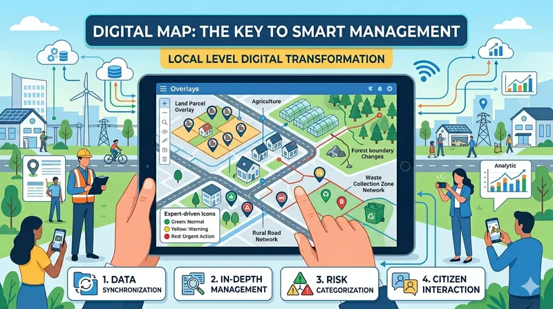
1. Synchronizing the “Spatial Data Warehouse” – The Foundation of Transparency
In state management, the consistency of planning data is a vital factor. Instead of scattered storage, management levels need to digitize and integrate all legal map layers: from Current Land Use Maps, Construction Planning to Cadastral Maps.
The breakthrough lies in bringing this “data warehouse” to mobile applications. Field officers can easily determine land parcel boundaries and compare the conformity between actual status and planning with just a few taps on their smartphone. This transparency not only helps accelerate document appraisal progress but also creates a clear, trustworthy investment environment for citizens and businesses.
2. Specialized Management With Powerful Interactive Tools
An effective management system goes beyond base maps and must delve into specific domains by digitizing management objects (Points, Lines, Areas):
- Land & Construction: Closely monitor construction order, especially high-tech agriculture models and land use purpose changes, ensuring all projects comply with architectural planning.
- Resources & Forestry: Continuously update forest boundary changes, promptly prevent encroachment on public land, and strictly manage mining activities.
- Transport & Environment: Digitize rural road networks for maintenance planning, while delineating pollution hotspots or waste collection areas for thorough treatment.
3. Smart Decision-Making Through Risk Classification Systems
The biggest change in digital transformation is changing the decision-making method. By applying intuitive icon systems and expert evaluation criteria, raw data transforms into “speaking information.”
For example, environmental hotspots can be displayed in colors: Green (Normal), Yellow (At Risk), and Red (Requires Urgent Action). Through an intuitive “digital sandbox,” leaders at all levels can grasp the local panorama in real-time. From there, directive policies are issued quickly and accurately, helping allocate resources to the right place, at the right time.
4. Harnessing the Power of Citizen Monitoring (Crowdsourcing)
The most successful digital transformation places citizens at the center. Granting limited access to citizens on the digital map platform creates a direct G2C (Government-to-Citizen) interaction channel.
When discovering issues such as construction violations, infrastructure damage, or environmental pollution, citizens can take photos, attach GPS coordinates, and submit feedback directly through the application. This “thousands of cameras powered by the people” helps the government receive objective information while also saving time and effort for citizens, thereby firmly strengthening community trust in the management apparatus.
Conclusion
Digitizing management is not just a technology story, but a story about service mindset and operational efficiency. A smart digital map system will be a solid launchpad for localities to move toward building a modern, transparent, and sustainable digital society.
TLGeo accompanies local governments with the digital map solution GeoCollect - GeoCloud - Plugin.